Cultural and natural landscapes of the Siegerland
The Siegerland is located in the south of the federal state of North Rhine-Westphalia. Geologically, the Siegerland belongs predominantly to the Rhenish Massif and to the Westerwald at its southern edge. The name "Siegerland" goes back to the river Sieg (= “region of the Sieg river”), a tributary of the Rhine.
The Siegerland is characterized by a rather harsh climate with high amounts of rainfall throughout the year. The Siegerland lies on the windward side of this central mountain range of Germany, which rises steadily from the Cologne Bay in the west to the Rothaargebirge in the east. Due to this geographic formations, the Seigerland often experiences uphill rains with considerable amounts of precipitation.
The unfavorable weather conditions and the geological conditions have led to the development of a special cultural and natural landscape mosaic in the Siegerland.
Historical perspective
The first colonization of the Siegerland
The Siegerland has a long settlement history, which dates back to as early as the Neolithic period, according to new studies. Around that time, early humans visited the region at least temporarily, even if they did not settle permanently. This early interest in the region was because of iron ore and high amounts of wood to process it. The consumption of wood in the melting furnaces of that time must have been immense, and presumably the native beech forests of the Siegerland region may have gone entirely through the coal piles and into the furnaces.
The forest in the vicinity of the charcoal kiln sites was (most likely) repeatedly felled. As beech trees could no longer reproduce sufficiently due to short time intervals between felling periods, the tree spectrum shifted towards birch and oak trees, especially as these are better to rejuvenate themselves than beech trees due to the removal of stumps. Pollen analyses support this assumption. Wood analyses from charcoal processing sites indicate that mainly five to twenty year old oak and birch trunks were charred so that it ca be assumed that coppice forests already existed in the Siegerland 2,400 years ago. This early forest use certainly turned out to be exploitation rather than sustainable use, especially since the grazing of the clear-cut areas with cattle and goats may also have prevented natural regeneration. It is further likely, that a settlement gap, which appears from about 200 to about 1000 AD, is due to the complete forest devastation in the region.
The peak of coppice forests
Starting in the 9th century and in the course of the Frankish internal colonization, a planned re-settlement of the region took place to further exploit the iron reservoirs. The good quality of the iron from the Siegerland, the great demand for iron and the improvement of melting furnaces caused the iron industry to expand again, which also led to another wood shortage during the centuries of the late Middle Age. The mountain slopes must have been extensively deforested at this time, again. From the 13th century onwards, the use of water power led to the establishment of ironworks and hammer mills in the larger valleys, which further expanded over time, e.g. in the Hüttental in Siegen. Consequently, the small Siegerland region had a flourishing iron industry towards the end of the 18th century.
In order to stop the overexploitation of the forests and to secure the supply of charcoal for iron melting, the “Forest and Timber Ordinance” was issued in 1562, which by then represented the first fundamental forestry law for the Siegerland. The “Jahnordnung“ of 1718 then regulated the amalgamation of all private woodlots. A cooperative joint ownership was created for each community. These community forests, or locally called “Hauberge” were then divided into 18 to 22 parts, which were then successively cut from year to year and left for rejuvenation for the rest of the time. Thus, no more wood was cut than could grew back. Each member of the logging community got an equal share, which was assigned by lot.
Between March 1 and April 20 of each year, all trees, except oaks and some overhanging trees, of the oldest felling part were cut and processed further. The small wood was tied into “Bürden”, the thin branches into “Schanzen”. These bundles of small wood were used to fuel the communal bakehouses, locally called "Backes". These bakehouses can still be found troughout the Sigerland today. After the cutting season in the Hauberg, people usually went on in May to peel the bark from the oak trees. The three to four meter long bark were left hanging on the trunks to dry, to be later brought to the tanneries as tan (“Lohe”). The oak poles, like the previously cut trunks, served as wood for the production of charcoal in the charcoal kilns.
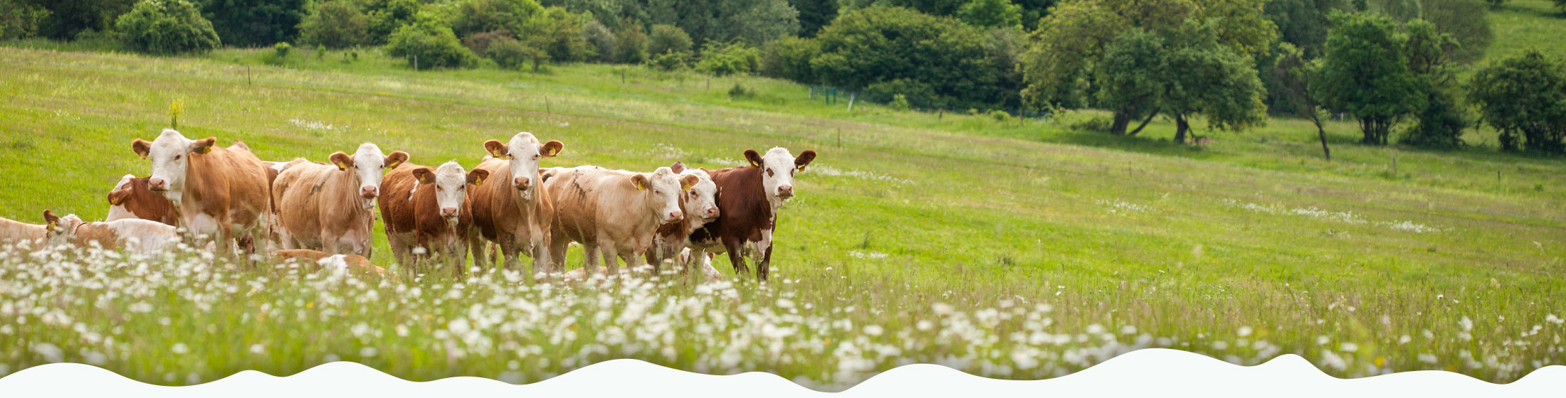
In order to expand the relatively small cultivation area for cereals and since cereal cultivation in the Siegerland was limited anyway by climatic unfavorability and nutrient-poor soils, the clear-cut forest areas were used in the year of use as additional cultivation area for buckwheat and rye (“Haubergskorn”). In preparation for sowing, the turfs were chopped loose in the summer and laid upside down to dry. Then the buckwheat could be sown, which was harvested in September. The dried turfs were burned after the buckwheat harvest to distribute the ashes as fertilizer for rye sowing. Winter rye was sown on the soil prepared in this way and plowed under shallowly with a wheel-less hook plow. All the implements used for soil cultivation were designed in such a way that the rootstocks of the trees were not injured. During harvesting in the following year, the resprouting trees had to be protected, so that the rye grain was carefully cut with a hand sickle. After the rye harvest, a six- to seven-year resting period began for the year's crop in question. After that, grazing cattle was allowed in the Hauberg. The cattle, equipped with neck bells (“Rotes Höhenvieh”, an ancient breed), ran freely as a herd and were herded by a shepherd. Assuming a grazing period of about 12 years on each of the 18-22 parts of the Hauberg, about 2/3 of the area was available for forest grazing during the summer months.
The combination of coppice, field and pasture use, which was strictly regulated by law in the Siegerland region, reconciled the needs of industry and agriculture. As elsewhere, the forest was not destroyed but expanded as far as possible. However, other tree species were pushed back in favor of the oak in particular.
The abandonment of the “Hauberg”
With the opening of the Ruhr-Sieg railroad in 1861, the decline of the Hauberg-cultivation, which had flourished until then, began. The charcoal from the Hauberg could not compete with the hard coal of the Ruhr area. Cheaper, foreign tanning bark and later the development of synthetic tanning agents led to a total drop in the price of oak tan from the Siegerland. The most important income of the Hauberg economy thus fell away and the coppice forest was more and more converted into high forests or timber forests. The annual felling areas were either left growing or cut areas were reforested, often with spruce. The creation of large-scale, communal grazing allotments (“Weidekämpen”) almost entirely replaced the forest grazing. After a temporary revival of the ancient Hauberg-cultivation after World War II, the forest management carried out today serves only for firewood production. With the Community Forest Act of North-Rhine Westphalia from 1975, all community forest ownership forms, including the Hauberg-communities (“Haubergsgenossenschaften”), became forest cooperatives, for which uniform rules apply.
Increasing importance of the grasslands
For centuries, haymaking as a minor activity was carried out by the cultivation of meadows. Only the moist valley bottoms were available for meadows, because Hauberg-areas were not allowed to be cleared to not endanger the production of charcoal and oak tan. Winter fodder for the cattle that was grazed in the Hauberg-areas had to be provided by the meadows. To increase the yield on the limited area, artificial irrigation was used.
Water was not a free good at that time. Hammer mills, ironworks, grain mills, fulling mills and tanning mills were located along the watercourses, and the use of water was regulated as early as the 15th century in order to provide sufficient water for irrigating the meadows. This was also in the interest of the iron industry, which needed larger quantities of fodder for its numerous work animals. The management of the meadows was regulated by meadow associations.
There were two approaches to the construction of irrigation systems. On slopes, an overhead ditch built above the meadows irrigated them stream water. This trickled over the meadows and flowed back to the stream in a catchment ditch. An artificial slope was created in the shallow floodplains. The entire area of the valley floor was completely redesigned for this purpose by creating roof-like meadow ridges. Such an artificial meadow consisted of several narrow-length lawn beds, with a trickle channel along the upper edge and drainage ditches along the lower edge. A feeder ditch branched off from the stream at the highest point of the area to be irrigated and fed the trickle ditches. The distribution of water was controlled by means of numerous sluices and weirs. From November to spring, the water from the stream, which was rich in suspended matter, was used to irrigate the meadows for fertilizing purposes, and in summer to protect them from drying out. This increased the hay yield by about one third of the normal yield.
At the beginning of the 19th century, the 6,500 hectares of meadows available in the Siegerland region had been almost completely converted into “trickle meadows”, locally called “Rieselwiesen”. The by then advanced meadow cultivation method had made the Siegerland meadow cultivation so famous that the method even spread over large parts of Germany. Nowadays, only traces of meadow cultivation can be found in some meadow valleys.
Iron industry - Hauberg cultivation - artificial meadows
The times of the iron extraction and processing were certainly characterized by the exploitation and destruction of habitats for people to make a living in the Siegerland. They usually worked as miners or in the processing of the ore, but were farmers at the same time. They produced firewood and charcoal for melting, tan for leather production, supplied harnesses for the work animals, protective clothing for the workers, built and managed the trickle meadows for haymaking and produced food in the form of grain, milk and meat, among others. Looking back, we can only admire the ingenuity and diligence of our ancestors.
Cultural landscapes
Due to the small-scale of different land use types and the high diversity of income generation strategies, a landscape mosaic constituting a multitude of habitats developed in the Siegerland. Depending on the stage of development after clear-cutting of Hauberg forests or meadows, a variety of plant and animal communities could coexist, ranging from early successional stages to bush- or heathlands to mature oak-birch forests. Due to these diverse successional stages, a variety of today rare and endangered species like the hazel grouse could benefit.
The long historical use of the Siegerland has led to the emergence of a unique cultural landscape, which still defines the image of the Siegerland today. In the open countryside, typical cultural landscapes include heathlands such as the Gambacher Heide in Burbach, Nardus-grasslands created by extensive grazing and numerous colorful flowering meadows such as lowland and mountain hay meadows were developed. Many of these cultural landscape formation are today particularly valuable habitats and valued by the EU Habitats Directive. In the forest area, the remaining coppice forests with their high proportions of oak trees are witnesses of the Hauberg cultivation and the iron production of the Siegerland.